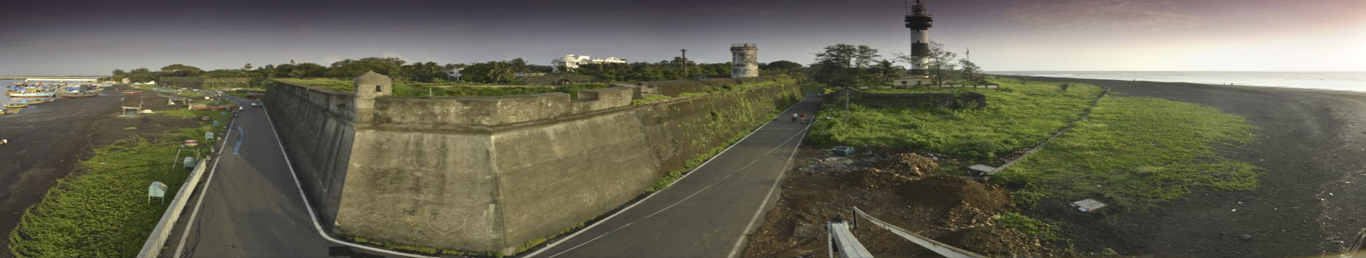
Daman and Diu, a union territory in west India, consists of 2 separate areas divided by the Arabian Sea. The Daman Ganga River flows through the coastal town of Daman. Diu is a small island and mainland village. The Fort of Moti Daman, Diu Fort and 16th-century churches reflect the territory’s past as a Portuguese colony. In the town of Moti Daman.
Daman and Diu history dates back to more than two thousand years. The region remained a part of the Lata Kingdom from the 2nd to the 13th century. The region was a part of Goa that came under the rule of the Portuguese in the 16th century. History of Daman and Diu reveals emergence of the region as an important political unit along with Goa. The region gained popularity after independence from the colonial regime of the Portuguese. The two districts remained a part of Goa till the year 1987 when Goa acceded to the Union of India and Daman and Diu became the union territory. Evidences excavated from the region of Surat unveil that the region was ruled by the Satrya Kshatrapas in the first century. The rule of the region passed to the Lata Kingdom which was one of the seven divisions of the Aparant or Konkan Vaishaya. Although the region was subjected to the rule of several dynasties during this period, the Lata Kingdom emerged as one of the most prominent rulers that dominated the history of Daman and Diu in the early centuries.
The Portuguese ruled the region for 450 years from 1510 to 1961. Goa achieved its independence from the colonial rule of the Portuguese in the year 1961. The state acceded to the Union of India in the year 1987. It was the same year that the region of Daman and Diu gained its status of a Union territory.
The entire area of Daman and Diu is taken up by two different districts called Daman and Diu. Both these districts are located on the seashore. Both of them have borderlines with the state of Gujarat. The district of Daman is situated close to the place called Surat in the southern part of Gujarat. The district of Diu is located close to the place called Junagadh in the peninsula called Saurashtra Peninsula in Gujarat. The region of Daman is a small region in the Gulf of Khambhat. The region of Diu is connected to the the state mainland by a creek.
Daman and Diu were both once parts of Goa. In the year 1987, after Goa was declared a separate state, Daman and Diu were separated from Goa. The three land expanses of Goa, Daman and Diu, which were located on the Indian west coast, functioned as a single political unit after getting independence from the Portuguese rule in the year 1961. Daman is located between 72-49'-42" and 72-54'-43" East longitudes and 20-22'-00" and 20-27'-25" North latitudes. Diu is located between 71°-00'-2'' and 70°-52'-26" East longitudes and 20°-44'-3'' and 20°-42'-00" North latitudes.
Daman and Diu geography is actually the geography of the districts of Daman and Diu, which make
up the union territory. The district of Daman is situated on the Indian west coast. This place
is bordered by a river called Kalem towards the south, a river called Bhagwan towards the north,
the Arabian Sea towards the west and the district of Valsad towards the east.
The Damanganga river divides the Daman district into two parts. Three rivers, namely, Bhagwan
River, Damanganga River and Kalem River pass through this district.
Daman has a moderate climate round the year because of its closeness to the sea. The average
rainfall received by the place throughout the year is 1687 mm. The average minimum temperature
of the place is 11°C and the average maximum temperature is 37°C. The ideal time to visit this
district of Daman and Diu is from September to April.
The district of Diu is located at a small distance away from the Kathiawar coast close to the
Veraval Port in the state of Gujarat.
It is located between 71°-00'-2'' and 70°-52'-2'' East longitudes and 20°-44'-3'' and
20°-42'-0'' North latitudes. The altitude of the district is 6 meters above the sea level.
The mainland of the district is linked with two bridges. Diu is bordered by Amreli and Junagadh
towards the north and the Arabian Sea towards the other three sides.
The climate of Diu is pleasant throughout the year. The rainy season stretches between June and
September. The summer temperature varies from 38°C to 15° C. The maximum rainfall is 63.5 cm.
The winter temperature varies between 20° and 25°C.
100
101
108/102
139
112
1091/181